
LotoSteve
New member
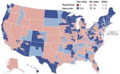
Professor Joseph Olson of Hemline University School of Law, St.Paul, Minnesota , points out facts of 2008 Presidential election:
Number of States won by:
Democrats: 19
Republicans: 29
Square miles of land won by:
Democrats: 580,000
Republicans: 2,427,000
Population of counties won by:
Democrats: 127 million
Republicans: 143 million
Murder rate per 100,000 residents in counties won by:
Democrats: 13.2
Republicans: 2.1
Professor Olson adds:
"In aggregate, the map of the territory Republican won by Republicans
was mostly the land owned by the taxpaying citizens of the country.
Democrat territory mostly encompassed those citizens living in
government-owned tenements and living off various forms of government
welfare. Professor Olson believes the United States is now somewhere between the "complacency and apathy" phase of Professor Tyler's definition of democracy, with some forty percent of the nation's population already
having reached the "governmental dependency" phase.
If Congress grants amnesty and citizenship to twenty million criminal invaders called illegals and they vote, then we can say goodbye
to the USA in fewer than five years.


")