Bobthebuilder
Charter Member
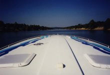
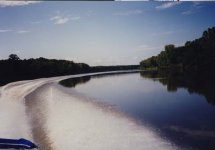
In September of 1998 after a great summer of boating on Lake Huron out of Port Huron, MI that included a memorable trip up to Macinaw Island, it was time to start thinking about getting “No Fear” back to it's winter home in SW Florida. I could put it on a trailer and have it hauled back as I had sometimes done in the past, or.... maybe I could drive it back on the inland river system. I had decided that with the weather starting to get a bit cool and unpredictable, that running Lakes Huron and Michigan over to Chicago and entering the river system there, was not such a good idea. A better idea I thought, would be to have it trailered to Cincinnati, OH and head down the rivers from there. I heard it could be done but knew little about it. I ordered all the charts and cruising guides I would need from Bluewater Charts and made arrangements to have the boat transported to Cincinnati. The charts were in a booklet form, easy to follow and would provide valuable ... and at times, misleading information as you will see later. The distance as measured by the mileage shown on the charts was 1,120 miles to Mobile, AL with a total of 19 locks to pass through. I would divide the trip up into two, four day segments and fly home for a break in between as well as tend to business. Part 1 would take us from Cincinnati to Cuba Landing, Tennessee and the second part, from there down to Mobile , AL. The original plan also included a third 600 mile segment from Mobile down the Gulf of Mexico to Marco Island, FL, however arriving hurricane “Georges” resulted in “No Fear” being pulled out of the water and placed on a trailer for land transportation to Marco. It turned out to be a good choice as much of Mobile, AL did in fact get hit hard with 13” of rain causing severe flooding.
Day 1
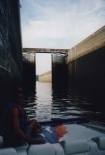
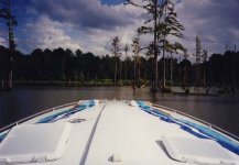
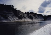
The first trip segment covered Cinci to Cuba Landing, Tennessee with my friend Laurie Richards coming along with me. We flew from Toronto down to Cinci and I remember arriving at the marina which was floating on poles that were at least 50 ft in the air. It was explained to me that when the Mississippi was flooding the year before, the water also backed up the Ohio Valley and that the marina was floating up near the top of the poles. I can't hardly imagine it, but apparently was true. Soon we were on our way, wanting to get to Louisville, KY that was just 138 miles down the river before dark. We passed a few barges along the way but few if any recreational boats. There would be 2 locks to pass through that afternoon as well. I recall that first night was spent at a Ramada Inn on the river across from Louisville.
Day 2
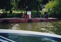
Our goal that second day, was to get as far as Evansville, IN some 188 miles downstream. There would be 3 locks to pass through on day 2 and that would slow our progress. Our fuel gauge showed lots of fuel yet, so a decision was made to get fuel later that day at one of the two marinas shown on the charts, downstream of the Louisville locks. Below the lock we watched the charts carefully for the first marina and it just was not there, so no problem we'll just continue to the next one. We arrive at where it was shown on the charts and .. you guessed it, not there either. Continuing down the river we hope that it has just been relocated but no such luck. Soon the fuel gauge is showing empty and I say to Laurie, “we have got to get off this river and figure this out or we are going to run out of fuel and drift until a barge runs over us.” I see a dock on the shore and we slide alongside and tie up. Laurie stays at the boat while I climb 60 ft up the embankment on a shaky set of stairs. At the top is some sort of trailer park / campground and no one to be found. I then approach a nearby farm house that as it turns out, is the campground office. The whole family comes out to see who this visitor is with the funny accent, eh. LOL I tell them of our predicament and the park manager was eager to help. He informs me that the marinas that we had been looking for, had been washed away the year before during the flooding. He says the nearest marina is 60 miles further downstream. He says he has a number of gas cans out at the barn and will take me the 5 miles into town for gas in his pickup truck. When he rounds up 5 cans ranging in size from 2 to 5 gals, I can see that this is not going to get us the 60 miles down the river and ask him if he has a 45 gal drum? Sure enough he does. Soon with all all our cans and drum filled, we arrive at the top of the embankment with our precious fuel. I borrow his 100 ft garden hose and with one end in the barrel and the other end 60 ft down the embankment at the boat, we get a siphon going. Did that work slick, and in a matter of minutes we had about 70 gals of fuel into “No Fear”. When we were finished, I offered him a $100 dollar bill and he said that was way too much money. I managed to convince him that without his help, we would have been in a real jamb and it was worth all of that and more to us. With some shyness and reluctance, he took it the money. Soon we were back on the water and on our way again. We continue down the Ohio river with Kentucky on our left and Indiana on our right arriving at Evansville, IN just after dark. We slept on the boat that night tying up at the fuel dock of a local marina rather than bother with a slip since no one was around. The next day we were up before anyone arrived and were on our way. I left them $20 bucks and a short thank you note stuck in the door. I wonder if they ever got it?
Day 3
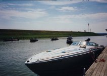
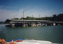
Mid morning we saw a good dock at some small town along the Ohio River and tied up. We were hungry and some onlookers informed us that there was a McDonald's on the other side of town and they would be happy to drive one of us there. So off I went with them while Laurie stood guard over the boat. We had our shore breakfast / lunch and were on our way again. Our goal that day was to cover 156 miles, traverse 3 more locks and arrive at Green Turtle Bay Marina, south of Paducah, KY before dark. From Evansville, IN to where we would leave the Ohio River and enter the Cumberland River would be 132 miles then just another 24 miles to Green Turtle Bay. Mission accomplished with nothing too exciting happening. I remember having the use of a loaner car at Green Turtle Bay that we were to return when they opened at 8 AM the next morning. So there we are at the office door at 8AM sharp and no one arrives to our puzzlement. We had to get on our way, so we left the keys and got on the water. Some time later that day we figured out that we were now far enough west that we were in a different time zone and that the time back at Green Turtle Bay was 7 AM and not our 8 AM EST. Too funny.
Day 4
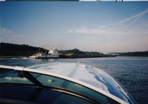
This would be a short day as we only had to travel 92 scenic, uneventful miles to Cuba Landing in Tennessee and no locks to contend with. Before noon we had “No Fear” secure and were on our way in a taxi the 60 miles to the Nashville, TN airport. We would arrive back in Toronto in time for dinner, completing the first phase of our trip. We had travelled 568 miles down the Ohio and Tennessee Rivers and passed thru 8 locks. The plan was for me to return in 10 days time with a fresh crew to continue on down the Tennessee - Tombigbee Waterway to Mobile, AL. That will be part 2 that I will write about sometime after the Miami boat show. I hope you enjoyed following along.
Bob
Day 1
The first trip segment covered Cinci to Cuba Landing, Tennessee with my friend Laurie Richards coming along with me. We flew from Toronto down to Cinci and I remember arriving at the marina which was floating on poles that were at least 50 ft in the air. It was explained to me that when the Mississippi was flooding the year before, the water also backed up the Ohio Valley and that the marina was floating up near the top of the poles. I can't hardly imagine it, but apparently was true. Soon we were on our way, wanting to get to Louisville, KY that was just 138 miles down the river before dark. We passed a few barges along the way but few if any recreational boats. There would be 2 locks to pass through that afternoon as well. I recall that first night was spent at a Ramada Inn on the river across from Louisville.
Day 2
Our goal that second day, was to get as far as Evansville, IN some 188 miles downstream. There would be 3 locks to pass through on day 2 and that would slow our progress. Our fuel gauge showed lots of fuel yet, so a decision was made to get fuel later that day at one of the two marinas shown on the charts, downstream of the Louisville locks. Below the lock we watched the charts carefully for the first marina and it just was not there, so no problem we'll just continue to the next one. We arrive at where it was shown on the charts and .. you guessed it, not there either. Continuing down the river we hope that it has just been relocated but no such luck. Soon the fuel gauge is showing empty and I say to Laurie, “we have got to get off this river and figure this out or we are going to run out of fuel and drift until a barge runs over us.” I see a dock on the shore and we slide alongside and tie up. Laurie stays at the boat while I climb 60 ft up the embankment on a shaky set of stairs. At the top is some sort of trailer park / campground and no one to be found. I then approach a nearby farm house that as it turns out, is the campground office. The whole family comes out to see who this visitor is with the funny accent, eh. LOL I tell them of our predicament and the park manager was eager to help. He informs me that the marinas that we had been looking for, had been washed away the year before during the flooding. He says the nearest marina is 60 miles further downstream. He says he has a number of gas cans out at the barn and will take me the 5 miles into town for gas in his pickup truck. When he rounds up 5 cans ranging in size from 2 to 5 gals, I can see that this is not going to get us the 60 miles down the river and ask him if he has a 45 gal drum? Sure enough he does. Soon with all all our cans and drum filled, we arrive at the top of the embankment with our precious fuel. I borrow his 100 ft garden hose and with one end in the barrel and the other end 60 ft down the embankment at the boat, we get a siphon going. Did that work slick, and in a matter of minutes we had about 70 gals of fuel into “No Fear”. When we were finished, I offered him a $100 dollar bill and he said that was way too much money. I managed to convince him that without his help, we would have been in a real jamb and it was worth all of that and more to us. With some shyness and reluctance, he took it the money. Soon we were back on the water and on our way again. We continue down the Ohio river with Kentucky on our left and Indiana on our right arriving at Evansville, IN just after dark. We slept on the boat that night tying up at the fuel dock of a local marina rather than bother with a slip since no one was around. The next day we were up before anyone arrived and were on our way. I left them $20 bucks and a short thank you note stuck in the door. I wonder if they ever got it?
Day 3
Mid morning we saw a good dock at some small town along the Ohio River and tied up. We were hungry and some onlookers informed us that there was a McDonald's on the other side of town and they would be happy to drive one of us there. So off I went with them while Laurie stood guard over the boat. We had our shore breakfast / lunch and were on our way again. Our goal that day was to cover 156 miles, traverse 3 more locks and arrive at Green Turtle Bay Marina, south of Paducah, KY before dark. From Evansville, IN to where we would leave the Ohio River and enter the Cumberland River would be 132 miles then just another 24 miles to Green Turtle Bay. Mission accomplished with nothing too exciting happening. I remember having the use of a loaner car at Green Turtle Bay that we were to return when they opened at 8 AM the next morning. So there we are at the office door at 8AM sharp and no one arrives to our puzzlement. We had to get on our way, so we left the keys and got on the water. Some time later that day we figured out that we were now far enough west that we were in a different time zone and that the time back at Green Turtle Bay was 7 AM and not our 8 AM EST. Too funny.
Day 4
This would be a short day as we only had to travel 92 scenic, uneventful miles to Cuba Landing in Tennessee and no locks to contend with. Before noon we had “No Fear” secure and were on our way in a taxi the 60 miles to the Nashville, TN airport. We would arrive back in Toronto in time for dinner, completing the first phase of our trip. We had travelled 568 miles down the Ohio and Tennessee Rivers and passed thru 8 locks. The plan was for me to return in 10 days time with a fresh crew to continue on down the Tennessee - Tombigbee Waterway to Mobile, AL. That will be part 2 that I will write about sometime after the Miami boat show. I hope you enjoyed following along.
Bob
Attachments
Last edited:
")