Noreaster?

The bar in south norfolk
 

Attachments

  • south+norfolk+flooding.jpg
    south+norfolk+flooding.jpg
    24.8 KB · Views: 4
  • shore+dr+norman+harrell2.jpg
    shore+dr+norman+harrell2.jpg
    46.3 KB · Views: 3
  • shore+dr+norman+harrell1.jpg
    shore+dr+norman+harrell1.jpg
    45.2 KB · Views: 2
:ack2::ack2::ack2:
 

Attachments

  • norfolk+wards+corner+tree+down.jpg
    norfolk+wards+corner+tree+down.jpg
    16.7 KB · Views: 4
  • norfolk+jay+rickards.jpg
    norfolk+jay+rickards.jpg
    32.1 KB · Views: 5
  • norfolk+clifford+st.jpg
    norfolk+clifford+st.jpg
    53.5 KB · Views: 5
wow, I live here and didnt see half those pic's on the news, awesome shot of the Ghost Ship that went adrift. Got one of the barge off Sandbridge?

Good work getting everyone back online!
 
wow, I live here and didnt see half those pic's on the news, awesome shot of the Ghost Ship that went adrift. Got one of the barge off Sandbridge?

Good work getting everyone back online!

Yup and Thanks
 

Attachments

  • barge_uscg1.jpg
    barge_uscg1.jpg
    25.8 KB · Views: 13
  • barge+ashore+sandbridge+pier.jpg
    barge+ashore+sandbridge+pier.jpg
    34.2 KB · Views: 9
  • barge+david+balsitis1.jpg
    barge+david+balsitis1.jpg
    38.5 KB · Views: 11
more
 

Attachments

  • sandbridgebarge4_111309.jpg
    sandbridgebarge4_111309.jpg
    22.9 KB · Views: 8
  • sandbridgebargefull.jpg
    sandbridgebargefull.jpg
    33.3 KB · Views: 11
  • barge+ashore+sandbridge+helo2.jpg
    barge+ashore+sandbridge+helo2.jpg
    27.1 KB · Views: 11
This was Wednesday 11/11 in Nomini VA. (below Colonial Beach) Didn't get it as bad but I guess it was time to get the ski boat off the lift for the winter. We had to use the tractor to get to the dock. :eek: 
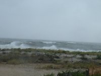
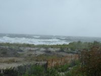
The water was high enough by Friday to probably float the boat off.
 

Attachments

  • shelleyboat.jpg
    shelleyboat.jpg
    55.9 KB · Views: 21
  • shelleyboat1.jpg
    shelleyboat1.jpg
    101.4 KB · Views: 22
Wow, you guys got hammered down south! We didn't get it half as bad up here, maybe a 4' tidal surge. Southern NJ got it worse than up by me.

They've declared state of emergency in all 6 coastal counties here in NJ and the beaches are in bad shape but not nearly as bad as you guys had it.

It's only a few days later and we have small craft advisories up again.... Unless the pattern changes the stage has been set for a long winter on the coastline.


...SMALL CRAFT ADVISORY IN EFFECT THROUGH THIS AFTERNOON...

.TODAY...E WINDS 10 TO 15 KT. SEAS 3 TO 6 FT. .TONIGHT...E WINDS 10 TO 15 KT. SEAS 3 TO 4 FT. .THU...E WINDS 10 TO 15 KT. SEAS 3 TO 4 FT IN THE MORNING AND 4 TO 6 FT IN THE AFTERNOON. A CHANCE OF LIGHT RAIN IN THE MORNING...THEN A CHANCE OF SHOWERS IN THE AFTERNOON. .THU NIGHT...SE WINDS 10 TO 15 KT WITH GUSTS UP TO 20 KT. SEAS 4 TO 6 FT. RAIN LIKELY. .FRI...W WINDS 10 TO 15 KT WITH GUSTS UP TO 20 KT. SEAS 3 TO 5 FT IN THE MORNING AND 2 TO 4 FT IN THE AFTERNOON. A CHANCE OF SHOWERS IN THE MORNING. .FRI NIGHT...NW WINDS 10 TO 15 KT WITH GUSTS UP TO 20 KT. SEAS 2 TO 4 FT. .SAT...N WINDS 10 TO 15 KT. SEAS 3 TO 5 FT. .SUN...NE WINDS 15 TO 20 KT. SEAS 4 TO 6 FT. A CHANCE OF RAIN.
 

Attachments

  • 0F932804-E1D8-4F64-8470-D7F58FE6A980.jpg
    0F932804-E1D8-4F64-8470-D7F58FE6A980.jpg
    37.3 KB · Views: 7
  • 6A334C1B-7843-4A9F-B467-1F8B38FEDD71.jpg
    6A334C1B-7843-4A9F-B467-1F8B38FEDD71.jpg
    45.5 KB · Views: 7
  • 5187AFB8-A1D9-4189-A4A6-57004D183821.jpg
    5187AFB8-A1D9-4189-A4A6-57004D183821.jpg
    50.8 KB · Views: 13
Thats not surf.....THIS IS SURF WEST COAST STYLE.....and we ain't riding bathtub waves!!!!!:26::26::26::26:

Also you can judge the size by the helicopter in one and the 6' surfer in the other one!!!!!!

Sean, here's some "West Coast" (centra america) footage of me back in 1998. Can't believe it's been 11 years now....:ack2:
 
Today was the day !!!

p78958753-4.jpg


p521773095-4.jpg


p8348936-4.jpg
 
The Nights In Rodanthe house NC Hwy 12 closed.

that pic of the house on stilts reminds me of a friends house that he rebuilt after the storm of 78. his had telephone poles which snaped with everyone elses in 78.so he rebuilt with hugh cement colums and steel beams in 90, we spent a night while it was this being built wanted to see how a northeaster would react on the house and the houses around him were falling apart again and his didn't creek like the others or twist up. he offered to rebuild the houses around him but people didn't want to spend the money:smash: so there lose. its still there but others have given up around him.
 
Winter is finally here.........

We're supposed to get 1-3" of snow in central NJ tonight. Can't wait to play with my daughter in it tomorrow!!!! :)
 
Frank . C'mon we're a little too close to the water for snow yet. I know it snowed last night but not gonna stick before christmas . Here's a couple pics from that storm a couple weks ago I forgot to post.
 

Attachments

  • 120509 130.jpg
    120509 130.jpg
    57.4 KB · Views: 4
  • 120509 131.jpg
    120509 131.jpg
    64.1 KB · Views: 5
  • 120509 132.jpg
    120509 132.jpg
    67 KB · Views: 4
The ocean is really p-issed off again.....:willy_nilly::willy_nilly: Tomorrow or later today should be a good surf day!:sifone:

Sandy Hook NJ to Fire Island Inlet NY out 20 nm - 10:17 AM EST Wed Dec 09 2009...Gale warning in effect through late tonight...

.Today...Se winds 25 to 30 kt with gusts up to 40 kt...Becoming
SW 15 to 20 kt with gusts up to 25 kt this afternoon. Seas 11 to
16 ft...
Subsiding to 9 to 12 ft this afternoon. A chance of rain
late this morning...Then a slight chance of rain this afternoon.
vsby 1 to 3 nm late this morning.
.Tonight...W winds 25 to 30 kt with gusts up to 45 kt. Seas 7 to
10 ft...Subsiding to 6 to 8 ft after midnight. A chance of showers
in the evening.
.Thu...W winds 25 to 30 kt with gusts up to 40 kt. Seas 6 to 9 ft.
.Thu night...W winds 25 to 30 kt with gusts up to 45 kt. Seas 6 to
9 ft.
.Fri...W winds 25 to 30 kt with gusts up to 45 kt. Seas 6 to 9 ft.
.Fri night...W winds 25 to 30 kt...Diminishing to 20 to 25 kt after
midnight. Seas 5 to 8 ft.
 
Issued by The National Weather Service
Philadelphia, PA
10:35 am EST, Wed., Dec. 9, 2009

... COASTAL FLOOD ADVISORY IN EFFECT UNTIL 5 PM EST THIS AFTERNOON...

THE NATIONAL WEATHER SERVICE IN MOUNT HOLLY HAS ISSUED A COASTAL FLOOD ADVISORY... WHICH IS IN EFFECT UNTIL 5 PM EST THIS AFTERNOON.

TIDAL DEPARTURES ALONG THE CENTRAL AND NORTHERN NEW JERSEY COAST WILL PRODUCE MINOR TIDAL FLOODING, POSSIBLY NEARLY MODERATE AT THE TIME OF HIGH TIDE THIS AFTERNOON.

HIGH TIDE AT SEASIDE HEIGHTS OCCURS AROUND 1 PM AND AT SANDY HOOK AROUND 130 PM. PLEASE MOVE YOUR VEHICLE BEFORE THE TIDE OF HIGH TIDE OCCURS.. HEAVY RAINS COMBINED WITH THE INCOMING TIDE HAS ADDED TO THE POTENTIAL FOR STREET FLOODING.

PRECAUTIONARY/PREPAREDNESS ACTIONS...

A COASTAL FLOOD ADVISORY INDICATES THAT ONSHORE WINDS AND TIDES WILL COMBINE TO GENERATE FLOODING OF LOW AREAS ALONG THE SHORE.
 
So much of that white crap here I had to make space for the car to thaw out in the garage at work...
 

Attachments

  • vt.jpg
    vt.jpg
    86.6 KB · Views: 16
  • vt2.jpg
    vt2.jpg
    113.2 KB · Views: 534
So much of that white crap here I had to make space for the car to thaw out in the garage at work...

Nice, looks like you got a pretty good dumping!:ack2: 57* and rain in NJ but strong winds last night...

Winds have already shifted offshore so the surf is starting to clean up!:sifone:
 

Attachments

  • latest.jpg
    latest.jpg
    73.2 KB · Views: 4
Anyone dreaming of a white Christmas????

"Winter Storm Takes Aim on Mid-Atlantic
by Tim Ballisty , on Dec 17, 2009 9:28 am ET
8am Friday Update: Computer weather models are not in complete agreement at this hour. The event is within 12 hours from beginning in the Southeast (SC, NC) so let's go with where our confidence is highest.

There will be a major snow event for western and central North Carolina. There will be a major snow event for nearly the entire state of Virginia.

Washington, DC - this is still a major snowstorm for you. Delaware, you are in the snow crosshairs too.

South Jersey, get ready for a plowable snow.

This is where things get tricky. Does the winter storm take more of an easterly track and move away from the big Northeast cities of the I-95 corridor.

Or does the winter storm, intensify into an even more powerful storm, head north and produce blizzard conditions for Philadelphia, New York City and eventually Boston.

That is the major question of the morning. We still don't have a concrete answer. But we'll continue to follow the latest updates through the morning.

In the meantime winter storm warnings and watches are plastered across the Mid-Atlantic and parts of the Northeast.

A blizzard watch is in effect for Long Island."
 
Back
Top