Noreaster?

Geronimo36

Charter Member
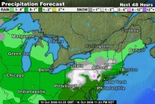
So I hear we're supposed to get our first Noreaster of the season already? also heard there might be snow up in the mountains?? WTF!!! Looks like it might be a long winter this year...:lurk5:

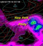
COASTAL WATERS FROM SANDY HOOK TO MANASQUAN INLET NJ OUT 20 NM- COASTAL WATERS FROM MANASQUAN INLET TO LITTLE EGG INLET NJ OUT 20 NM- 902 PM EDT WED OCT 14 2009
...SMALL CRAFT ADVISORY IN EFFECT THURSDAY AFTERNOON... ...GALE WATCH IN EFFECT FROM THURSDAY EVENING THROUGH FRIDAY AFTERNOON...


THU...NE WINDS 15 TO 20 KT...INCREASING TO 20 TO 25 KT WITH GUSTS TO 30 KT IN THE AFTERNOON. SEAS 2 TO 4 FT...BUILDING TO 4 TO 6 FT. RAIN. .THU NIGHT...NE WINDS 25 TO 30 KT WITH GUSTS UP TO 40 KT. SEAS 6 TO 9 FT...BUILDING TO 8 TO 12 FT. RAIN. .FRI...NE WINDS 25 TO 30 KT WITH GUSTS UP TO 40 KT. SEAS 8 TO 12 FT. RAIN. .FRI NIGHT...NE WINDS 25 TO 30 KT. SEAS 6 TO 9 FT. RAIN LIKELY. .SAT...NE WINDS 20 TO 25 KT WITH GUSTS UP TO 30 KT. SEAS 5 TO 8 FT. RAIN LIKELY. .SAT NIGHT...NE WINDS 15 TO 20 KT WITH GUSTS UP TO 25 KT. SEAS 4 TO 7 FT. RAIN LIKELY. .SUN...N WINDS 15 TO 20 KT. SEAS 4 TO 7 FT...SUBSIDING TO 3 TO 5 FT. RAIN LIKELY DURING THE DAY...THEN A CHANCE OF SHOWERS. .MON...NW WINDS 10 TO 15 KT. SEAS 3 TO 5 FT. A CHANCE OF SHOWERS IN THE MORNING.
 
Issued by The National Weather Service
Philadelphia, PA
2:41 pm EDT, Wed., Oct. 14, 2009

... COASTAL FLOOD WATCH NOW IN EFFECT FROM LATE THURSDAY NIGHT THROUGH FRIDAY EVENING...

THE COASTAL FLOOD WATCH IS NOW IN EFFECT FROM LATE THURSDAY NIGHT THROUGH FRIDAY EVENING.

STIFF EAST TO NORTHEAST WINDS FROM LATE THURSDAY THROUGH FRIDAY WILL RESULT IN RISING TIDES ALONG THE ATLANTIC OCEANFRONT... RARITAN BAY... DELAWARE BAY AND ADJACENT BACK BAYS.

FOR THE THURSDAY EVENING HIGH TIDE... WIDESPREAD MINOR TIDAL FLOODING IS POSSIBLE. ALONG THE ATLANTIC OCEANFRONT AND RARITAN BAY... HIGH TIDE OCCURS BETWEEN 530 PM AND 630 PM EDT. HIGH TIDE ALONG ADJACENT BACK BAYS AND DELAWARE BAY OCCURS UP TO A FEW HOURS LATER.

FOR THE SUBSEQUENT HIGH TIDES ON FRIDAY... MODERATE TIDAL FLOODING IS POSSIBLE. ALONG THE ATLANTIC OCEANFRONT AND RARITAN BAY THE FRIDAY MORNING HIGH TIDE OCCURS BETWEEN 615 AM AND 715 AM EDT... AND THE FRIDAY EVENING HIGH TIDE OCCURS BETWEEN 630 PM AND 730 PM EDT. AGAIN... HIGH TIDE ALONG ADJACENT BACK BAYS AND DELAWARE BAY OCCURS UP TO A FEW HOURS LATER.

FOR THE FRIDAY HIGH TIDES... POSSIBLE TIDE HEIGHTS ARE 8.0 TO 8.5 FEET MLLW AT SANDY HOOK... 7.5 TO 8.0 FEET MLLW AT SEASIDE HEIGHTS AND ATLANTIC CITY... AROUND 8.0 FEET MLLW AT CAPE MAY... BETWEEN 7.0 AND 7.5 FEET MLLW AT REHOBOTH BEACH AND BREAKWATER HARBOR... AND BETWEEN 8.0 AND 8.5 FEET MLLW AT REEDY POINT.

ANY RAINFALL OCCURRING DURING THE TIMES OF HIGH TIDE WOULD EXACERBATE TIDAL FLOODING... AND WAVE ACTION MAY LEAD TO MODERATE BEACH EROSION.

PRECAUTIONARY/PREPAREDNESS ACTIONS...

A COASTAL FLOOD WATCH MEANS THAT CONDITIONS FAVORABLE FOR FLOODING ARE EXPECTED TO DEVELOP. COASTAL RESIDENTS SHOULD BE ALERT FOR LATER STATEMENTS OR WARNINGS... AND TAKE ACTION TO PROTECT PROPERTY.
 
Issued by The National Weather Service
Philadelphia, PA
2:51 pm EDT, Wed., Oct. 14, 2009

... WIND ADVISORY IN EFFECT FROM 6 PM THURSDAY TO 6 PM EDT FRIDAY...

THE NATIONAL WEATHER SERVICE IN MOUNT HOLLY HAS ISSUED A WIND ADVISORY... WHICH IS IN EFFECT FROM 6 PM THURSDAY TO 6 PM EDT FRIDAY. THE HIGH WIND WATCH IS NO LONGER IN EFFECT.

A DEVELOPING COASTAL STORM WILL CAUSE WINDS TO INCREASE THURSDAY. NORTHEAST WINDS THURSDAY NIGHT AND FRIDAY ARE FORECAST TO INCREASE TO 20 TO 30 MILES AN HOUR... WITH GUSTS OF AROUND 45 MILES AN HOUR.

THE COMBINATION OF THE PERSISTENCE OF THE STRONG NORTHEAST WINDS, THE RAIN AND LEAVES STILL ON TREES WILL CAUSE TREE LIMBS AND WEAKER TREES TO FALL DOWN AND CAUSE SCATTERED POWER OUTAGES.

THE WINDS ARE EXPECTED TO SLOWLY DIMINISH FRIDAY NIGHT AS THE STORM RECEDES TO THE NORTHEAST.

PRECAUTIONARY/PREPAREDNESS ACTIONS...

A WIND ADVISORY MEANS THAT WIND GUSTS OF AROUND 45 MPH OR HIGHER ARE LIKELY. WINDS THIS STRONG CAN MAKE DRIVING DIFFICULT... ESPECIALLY FOR HIGH PROFILE VEHICLES. WEAK TREE LIMBS AND SHALLOW ROOTED TREES MIGHT GET KNOCKED DOWN. USE EXTRA CAUTION.
 
Coastal storm off the Jersey and Delaware coast on Thursday night
Image credit: wright-weather.com

A wet, windy and snowy storm system will visit the Mid-Atlantic on Thursday afternoon.

With plenty of moisture and mid-level energy sweeping through the Ohio and Tennessee Valleys, a coastal storm will develop off the Carolina coast on Thursday and quickly strengthen.

By Thursday night, it will be positioned just off the Mid-Atlantic coast.

Strong, easterly winds will develop off the Atlantic and sweep onshore. Gusts to 50 or even 60 mph are expect to impact coastal locations over Delaware, New Jersey and Long Island.

As expected, wind advisories and high wind warnings are in place. Delaware | New Jersey

Along with the gusty onshore winds comes the threat for coastal flooding.

Onshore winds will allow for higher than average tide levels and give way to water making its way farther inland along the coast.

Coast flood advisories: New Jersey | Delaware | Connecticut | New York

This is a quick-hitting storm. It will be moving away from the Mid-Atlantic coast by Friday afternoon (if not earlier) and the southern New England coast by Friday night.

Moisture from this storm system will also spill into the higher elevations of central Pennsylvania.

It's here where a heavy wet snow is expected to fall beginning Thursday afternoon and into the early morning hours of Friday.

This is an early season storm and trees still have plenty of leaves.

The National Weather Service warns that if several inches of snow accumulates on trees, significant tree damage and damage to power lines will likely result.
 

Attachments

  • coastalstorm1014.jpg
    coastalstorm1014.jpg
    84.6 KB · Views: 6
  • spec_trop9_720x486.jpg
    spec_trop9_720x486.jpg
    48.3 KB · Views: 14
Glad i bought a couple of sleds this year :D

Sledding is one thing that I've always wanted to but have never done.....
I guess on one of these ski trips I'll have to rent one.

Speaking of Snow, how about a local SO ski-trip this winter? Killington, Mt. Snow etc.????:26:
 
Speaking of Snow, how about a local SO ski-trip this winter? Killington, Mt. Snow etc.????:26:


when do you go skiing up there? Heck i'm in for a SO ski trip. I usually take a week an a half over Christmas and new years and head up to Miane/Vermont/New Hampshire For skiing and climbing/hiking in the White Mountains area. My favorite place to ski is Sunday River or Jay Peak followed by Killington (best night life)
 
We got ours already 2 days ago...Damn...winds up to 40 and freezing.
but the temps should pick up back to normal next week in the 40´s
 
Actually the Gulfstream keeps us warm..so I have to come over to Key West to check where it starts from :)

And I wouldn't ´t mind If we wouldn´t get any snow.
Last year we didn´t get any snow to even ski enough until late February and it lasted for about a month. But that´s only southwestern Finland I speak of...
Our Rivers haven´t frozen over last winter so you could even walk on the Ice either.
And That´s got nothing to do with global warming. That´s basically Our climate, close to yours in Northeast.
 
when do you go skiing up there? Heck i'm in for a SO ski trip. I usually take a week an a half over Christmas and new years and head up to Miane/Vermont/New Hampshire For skiing and climbing/hiking in the White Mountains area. My favorite place to ski is Sunday River or Jay Peak followed by Killington (best night life)

I usually try to start going right after Christmas. One year we were @ Killington for New Years and another year @ Hunter, great times!!! I like going early and late to beat the -20 degree weather days...

I haven't gone to Sunday River or Jay Peak but would like to go sometime! How are those mountains, are they snowboard friendly?

Can't beat the nightlife in Killington!!! "Wobbly Barn" :sifone:
 
I hope it's a nasty winter. Gonna try to break 1000 miles on the sled this year for the first time since '03.
 
I had a house walking distance from the wobbly barn , thank god. Nite spot for happy hour apres ski for a couple goombay smashes and some pizza from that wood fired oven. Hit the wobbly late if we were still standing . Those were the days. I want to ski but my knees say NO GO !!!!!
 
I usually try to start going right after Christmas. One year we were @ Killington for New Years and another year @ Hunter, great times!!! I like going early and late to beat the -20 degree weather days...

I haven't gone to Sunday River or Jay Peak but would like to go sometime! How are those mountains, are they snowboard friendly?

Can't beat the nightlife in Killington!!! "Wobbly Barn" :sifone:

That's not early. Every year for the last 15 years, me and a couple buddies head up to Killington right after Thanksgiving dinner. :sifone:

Only 1 year ever did we not snowboard. That year, they got about 2 feet of new snow 2 weeks before Thanksgiving. The week of Thanksgiving, it was in the 50's and raining every day. By the time we got there, there were like 2 trails open, so we just drank the whole weekend.

Happy hour at Outback Pizza. :biggrinjester:

Nice!!!

Who knows, maybe that was one of the times my wife and I went!!!

It was a few years ago, I'd say 2002-2003 timeframe. We went with another couple rented a condo at Ascutney about 1-2 weeks before Thanksgiving... Rates were cheap and we hoped to get a little time on the slopes.. Ascutney had no snow, it was 60 degrees and raining and Killington had like 1-2 trailes open with some major dry spots. :(

On a positive note, we partied the whole weekend and still had a great time!:26:

Do you think you're going to do the Killington thing this year? I might be interested in meeting up.... speaking of Killington, here's a few pics I have on my work PC.
 

Attachments

  • n690518532_1214497_7114.jpg
    n690518532_1214497_7114.jpg
    48.4 KB · Views: 13
  • n690518532_1214496_6827.jpg
    n690518532_1214496_6827.jpg
    56.3 KB · Views: 11
  • n690518532_1200569_8330.jpg
    n690518532_1200569_8330.jpg
    34.4 KB · Views: 8
Last edited:
I had a house walking distance from the wobbly barn , thank god. Nite spot for happy hour apres ski for a couple goombay smashes and some pizza from that wood fired oven. Hit the wobbly late if we were still standing . Those were the days. I want to ski but my knees say NO GO !!!!!

No worries John, they got you covered! Just get one of those sit-down ski's!!! :rofl:
 

Attachments

  • turns02.jpg
    turns02.jpg
    46.4 KB · Views: 6
Coastal storm off the Jersey and Delaware coast on Thursday night
Image credit: wright-weather.com

A wet, windy and snowy storm system will visit the Mid-Atlantic on Thursday afternoon.

With plenty of moisture and mid-level energy sweeping through the Ohio and Tennessee Valleys, a coastal storm will develop off the Carolina coast on Thursday and quickly strengthen.

By Thursday night, it will be positioned just off the Mid-Atlantic coast.

Strong, easterly winds will develop off the Atlantic and sweep onshore. Gusts to 50 or even 60 mph are expect to impact coastal locations over Delaware, New Jersey and Long Island.

As expected, wind advisories and high wind warnings are in place. Delaware | New Jersey

Along with the gusty onshore winds comes the threat for coastal flooding.

Onshore winds will allow for higher than average tide levels and give way to water making its way farther inland along the coast.

Coast flood advisories: New Jersey | Delaware | Connecticut | New York

This is a quick-hitting storm. It will be moving away from the Mid-Atlantic coast by Friday afternoon (if not earlier) and the southern New England coast by Friday night.

Moisture from this storm system will also spill into the higher elevations of central Pennsylvania.

It's here where a heavy wet snow is expected to fall beginning Thursday afternoon and into the early morning hours of Friday.

This is an early season storm and trees still have plenty of leaves.

The National Weather Service warns that if several inches of snow accumulates on trees, significant tree damage and damage to power lines will likely result.


I was in Ocean City at 11:00 AM, it is not a very good boating day at the Jersey shore (I am kidding). There was one fisherman in the ICW near the 14th street bridge in a 18' - 20' runabout. I will give that fisherman his due, it was raining heavy, cold, and windy...I know I would not want to be out there on the water today, or even walking down the street. Nasty day.
 
Last edited:
Back
Top